Lockhart Basin

On my list of to do’s in Canyonlands has always been a drive of the Lockhart Basin road. After cruise Moab 2011 I had a chance to make this drive, Alan had time in his schedule to accompany my for part of the drive.
We left Moab an headed west from town on the Kane Creek Road. We climbed Hurrah Pass with a quick stop at the top then on towards Chicken Corners and the start of the Lockhart Basin road. We had a “not so” short detour taking a wrong turn up the wrong canyon, a common mistake on this route.

The climb up from the Colorado at the start of the Lockhart Basin road is the most technical section. There are a few section where there is a risk of rolling the FJ. Getting off the right line Allen found one of these sections. With his FJ being held from rolling by a single boulder a recovery was in order. We used my winch with a redirect to keep the FJ from rolling and Allan used his winch to pull the FJ out. A conservative recovery but it worked well.

Once we topped out the views were spectacular.

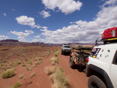
- Wide open places


We found a great camp on a side spur that heads down Lockhart Canyon to the Colorado.
Lockhart Day 1 Google KML file
We are considering riding our lighter Dual-Sport motorcycles down the Lockhart Basin Road from north to south. The more recent maps list “Extreme Difficult 4WD section” in about three places. I can’t seem to get clear info on just how difficult these places are. We ‘ve all been riding dirt bikes around Moab for 30 years so we’re used to some difficuly sections but I also don’t want to get anyone hurt down there either. If we ride north to south, would the most difficult places (shown about 6 and 10 miles south of the Hurrah Pass summit) be up-hill or downhill? We can go downhill on really hard places easier than having to attack so hard to go uphill especially if the road has loose rocks…easier for the bikes on the sandstone places with ledges than loose rocks. I liked your pictures and any opinion on the difficulty on the upper parts of Lockhart Basin Road would be appreciated. Thank, Ken Harrell.
We’d like to ride our lighter dual sport bikes down Lockhart Basin road from north to south. What is your opinion of just how difficult those map-listed “Extreme 4WD Sections” really are. And are the difficult sections loose rock of sandstone areas with ledges. Any opinions would be welcome. Thanks, Ken Harrell
My buddy and I just got back from a Moab trip. I had been planning a multi-day Lockhart “expedition”, and enjoyed using your KML file as a resource. We even went down into the beginning of Lockhard Canyon to see if we could find your camping spot from 2011, but never really found it. I was shocked at how challenging the first mile of the Lockhart Road is (going North-to-South obviously.) I almost turned around at the part above where the guy slipped off the rock and needed recovery. Fortunately I trust my buddy spotting, so we made it up and over with no issues. What a rush!
Glad that you had a great trip. The views are fantastic.